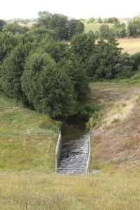
It starts at Cheronnac with a man and a bowser of water! Well maybe, but the explanation to that is on a previous blog along with some photos of the source. Here is just one.There are others on Google earth so you can click through to see exactly where I took the photographs. Also whilst you are on Google earth, I have put several of the photos of these upper reaches of the Charente on Panoramio which is the photo section of google earth; also you can click on alan waterman to see all my other photos from all over the world, well almost. Here I will save you the bother just click alan waterman and you will be there in a jiffy.)
It then flows for 12 Km through Haute Vienne until it enters the artificial Lake Lavaud. I stopped on the way and took one photo of it near a settlement called La Feranchie. ( google earth link)
The small river spreads out to form Lake Lavaud near a place called Le Moulin Paute on the D374. I did not see a Moulin. There were 3 English people walking down the road who said Bonjour to me and there was a Grey Heron on the distant edge of the lake. There was also a small wading bird, possibly a Common Sandpiper, which flew off as I approached. (google earth link)
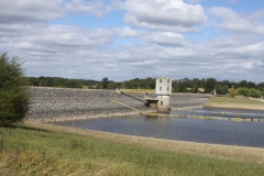
Next stop for us was the dam at the top end of Lake Lavaud, which is close to the village of St Quentin-sur-Charente, which it is not – it is pres de Charente but I suppose that does not sound so good. The lake was created in 1990 and is approximately 22 hectares in size. It has a beach and various areas are demarcated for sailing, fishing or as a nature reserve. There are camping facillites and gites dotted around. For more info visit the Lake Lavaud website
On the other side of the dam the little river continues its natural course. (Google earth link)
Our next stop was on the D16 near Le Machenet. Here I saw some otter spraints. That is the polite term used to describe otter shit which they often leave in a prominent place on the river bank to mark their territory. (Google earth link)

Onward and the river was by now becoming more substantial. Our last but one stop on this adventure was near the village of Le Breuil on the D345 just off the D169.
Finally we passed through Ambernac and Alloue. Here we could follow the river on the left hand bank up to Benest and eventually Chatain or the right hand bank direct to Chatain. We chose the Benest route as we had come down the other way. Both routes have some merit. The road to Benest runs close to the river and there are good views of it. The other route is further from the river but passes along some high ground with excellent views across the now developing Charente valley. (Google earth link)


Many thanks for your blog, a very interesting read. I was especially interested in the photos of the lake.
I visited the area some years ago, and recently tried to re-visit, but was not able to find the site of my first visit. Am I right in thinking that there is a “glory hole” close to the dam?
Maybe if you click the link to Google earth which is on my post then you will be able to refresh your memory as to the exact location you visited and rediscover the “glory hole” , whatever that is..
Pingback: La Charente at Rochefort « poitoucharentesinphotos
Pingback: Village Flottant | Poitoucharentesinphotos